Arkansas: Komplet liste over 75 amter og amtssæder
Arkansas: Komplet liste over alle 75 amter og deres amtssæder — find hurtigt hvert amts navn, amtssæde og de 10 amter med dobbelte sæder.
Billedgalleri
3 Billeder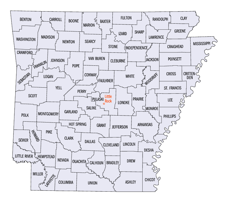
| Amt | FIPS-kode | Amtssæde | Etableret | Oprindelse | Betydning af navnet | Befolkning | Område | Kort |
| Arkansas County | 001 | De Witt og | 1813 | 1st County (Østlige Arkansas) | En måde at sige Quapaw indianske indianere på | 7004190190000000000♠19,019 | 70029880000000000000000♠988 km2 |
|
| Ashley County | 003 | Hamburg | 1848 | Drew og Union amter | Chester Ashley (1791-1848), en amerikansk senator fra Arkansas | 7004218530000000000♠21,853 | 70029210000000000000000♠921 km2 |
|
| Baxter County | 005 | Mountain Home | 1873 | Fulton, Izard, Marion og Searcy amter | Elisha Baxter (1827-1899), guvernør i Arkansas | 7004415130000000000♠41,513 | 70025540000000000000000♠554 km2 |
|
| Benton County | 007 | Bentonville | 1836 | Washington County | Thomas Hart Benton (1782-1858), en amerikansk senator fra Missouri | 7005221339000000000♠221,339 | 70028430000000000000000♠843 km2 |
|
| Boone County | 009 | Harrison | 1869 | Carroll og Marion amter | Daniel Boone (1734-1820), den amerikanske grænsemand | 7004369030000000000♠36,903 | 700259100000000000000000000♠591 km2 |
|
| Bradley County | 011 | Warren | 1840 | Union County | Hugh Bradley, en soldat i krigen i 1812 og tidlig bosætter i området | 7004115080000000000♠11,508 | 70026510000000000000000♠651 km2 |
|
| Calhoun County | 013 | Hampton | 1850 | Dallas og Ouachita amter | John C. Calhoun (1782-1850), USA's syvende vicepræsident og senator fra South Carolina | 7003536800000000000♠5,368 | 70026280000000000000000♠628 km2 |
|
| Carroll County | 015 | Berryville og | 1833 | Izard County og senere Madison County (1870) | Charles Carroll (1737-1832), underskriver af uafhængighedserklæringen | 7004274460000000000♠27,446 | 70026340000000000000000♠634 km2 |
|
| Chicot County | 017 | Lake Village | 1823 | Arkansas County | Point Chicot ved Mississippi-floden | 7004118000000000000♠11,800 | 70026440000000000000000♠644 km2 |
|
| Clark County | 019 | Arkadelphia | 1818 | Arkansas (1818) | William Clark (1770-1838), opdagelsesrejsende og guvernør i Missouri-territoriet | 7004229950000000000♠22,995 | 70028660000000000000000♠866 km2 |
|
| Clay County | 021 | Piggott og | 1873 | Randolph og Greene counties, og oprindeligt hed det Clayton før 1875 | John Clayton, senator; senere forkortet til Clayton for at | 7004160830000000000♠16,083 | 70026390000000000000000♠639 km2 |
|
| Cleburne County | 023 | Heber Springs | 1883 | White, Van Buren og Independence amter | Patrick Cleburne (1828-1864), en konfødereret general i borgerkrigen | 7004259700000000000♠25,970 | 70025530000000000000000♠553 km2 |
|
| Cleveland County | 025 | Rison | 1873 | Bradley, Dallas, Jefferson counties, og tidligere Dorsey County (fra 1885) | Grover Cleveland (1837-1908), USA's 22. og 24. præsident | 7003868900000000000♠8,689 | 70025980000000000000000♠598 km2 |
|
| Columbia County | 027 | Magnolia | 1852 | Oprettet af amterne Lafayette, Hempstead og Ouachita | Columbia, en kvindelig personifikation af USA | 7004245520000000000♠24,552 | 70027660000000000000000♠766 km2 |
|
| Conway County | 029 | Morrilton | 1825 | Pulaski County | Henry Wharton Conway (1793-1827), territorial delegeret til Repræsentanternes Hus i USA | 7004212730000000000♠21,273 | 70025560000000000000000♠556 km2 |
|
| Craighead County | 031 | Jonesboro og | 1859 | Mississippi, Greene, Poinsett amter | Thomas Craighead (1798-1862), en statssenator, der ironisk nok var imod oprettelsen af amtet | 7004964430000000000♠96,443 | 70027110000000000000000♠711 km2 |
|
| Crawford County | 033 | Van Buren | 1820 | Pulaski County | William H. Crawford (1772-1834), politiker, der var finansminister og krigsminister | 7004619480000000000♠61,948 | 70025960000000000000000♠596 km2 |
|
| Crittenden County | 035 | Marion | 1825 | Phillips County | Robert Crittenden (1797-1834), guvernør i Arkansas-territoriet | 7004509020000000000♠50,902 | 70026100000000000000000♠610 km2 |
|
| Cross County | 037 | Wynne | 1862 | St. Francis, Poinsett og Crittenden amter | David C. Cross, en konfødereret soldat i borgerkrigen og lokal politiker | 7004178700000000000♠17,870 | 70026160000000000000000♠616 km2 |
|
| Dallas County | 039 | Fordyce | 1845 | Clark og Bradley amter | George M. Dallas (1792-1864), USA's 11. vicepræsident | 7003811600000000000♠8,116 | 70026680000000000000000♠668 km2 |
|
| Desha County | 041 | Arkansas City | 1838 | Arkansas, Union counties, derefter fra Chicot County (før 1880), og Lincoln (før 1930) | Benjamin Desha, en soldat i krigen i 1812 | 7004130080000000000♠13,008 | 70027650000000000000000♠765 km2 |
|
| Drew County | 043 | Monticello | 1846 | Bradley, Chicot, Desha, Union amter | Thomas Stevenson Drew (1802-1879), 3. guvernør i Arkansas | 7004185090000000000♠18,509 | 7002828280000000000000000♠828 km2 |
|
| Faulkner County | 045 | Conway | 1873 | Pulaski og Conway amter | Sanford Faulkner (1806-1874), en konføderationssoldat og komponist af sangen "The Arkansas Traveler" | 7005113237000000000♠113,237 | 70026470000000000000000♠647 km2 |
|
| Franklin County | 047 | Ozark og | 1837 | Crawford og Johnson amter | Benjamin Franklin (1706-1790), grundlægger af USA | 7004181250000000000♠18,125 | 70026100000000000000000♠610 km2 |
|
| Fulton County | 049 | Salem | 1842 | Izard County og senere fra Lawrence County (før 1850) | William Savin Fulton (1795-1844), den sidste guvernør i Arkansas-territoriet før statsdannelsen | 7004122450000000000♠12,245 | 70026180000000000000000♠618 km2 |
|
| Garland County | 051 | Varme kilder | 1873 | Montgomery, Hot Springs og Saline amter | Augustus Hill Garland (1832-1899), amerikansk senator og 11. guvernør i Arkansas | 7004960240000000000♠96,024 | 70026780000000000000000♠678 km2 |
|
| Grant County | 053 | Sheridan | 1869 | Jefferson, Hot Spring, Saline amter | Ulysses Simpson Grant (1822-1885), USA's 18. præsident | 7004178530000000000♠17,853 | 70026320000000000000000♠632 km2 |
|
| Greene County | 055 | Paragould | 1833 | Lawrence County og senere af Randolph | Nathanael Greene (1742-1786), general fra revolutionskrigen | 7004420900000000000♠42,090 | 70025780000000000000000♠578 km2 |
|
| Hempstead County | 057 | Håb | 1818 | Arkansas (1818) | Edward Hempstead (1780-1817), delegeret til det amerikanske Repræsentanternes Hus fra Missouri-territoriet | 7004226090000000000♠22,609 | 70027290000000000000000♠729 km2 |
|
| Hot Spring County | 059 | Malvern | 1829 | Clark County og senere fra Montgomery County (før 1880) | Naturligt forekommende varme kilder i amtet | 7004329230000000000♠32,923 | 70026150000000000000000♠615 km2 |
|
| Howard County | 061 | Nashville | 1873 | Pike, Hempstead, Polk, Sevier amter. | James H. Howard, en senator fra Arkansas | 7004137890000000000♠13,789 | 70025880000000000000000♠588 km2 |
|
| Independence County | 063 | Batesville | 1820 | Lawrence County (1820) | Uafhængighedserklæringen | 7004366470000000000♠36,647 | 70027640000000000000000♠764 km2 |
|
| Izard County | 065 | Melbourne | 1825 | Independence, Crawford counties, og senere fra Fulton (før 1880) | George Izard (1776-1828), guvernør i Missouri-territoriet og general under krigen i 1812 | 7004136960000000000♠13,696 | 70025810000000000000000♠581 km2 |
|
| Jackson County | 067 | Newport | 1829 | Lawrence og St. Francis amter | Andrew Jackson (1767-1845), USA's syvende præsident | 7004179970000000000♠17,997 | 70026340000000000000000♠634 km2 |
|
| Jefferson County | 069 | Pine Bluff | 1829 | Arkansas og Pulaski | Thomas Jefferson (1743-1826), USA's tredje præsident | 7004774350000000000♠77,435 | 70028850000000000000000♠885 km2 |
|
| Johnson County | 071 | Clarksville | 1833 | Pope County, og en lille del fra Madison County (før 1890) | Benjamin Johnson (1784-1849), den første dommer ved den føderale distriktsdomstol for Arkansas | 7004255400000000000♠25,540 | 70026620000000000000000♠662 km2 |
|
| Lafayette County | 073 | Lewisville | 1827 | Hempstead County og senere fra Columbia County (før 1910) | Marquis de la Fayette (1757-1834), en franskmand, der var general i den kontinentale hær under revolutionskrigen | 7003764500000000000♠7,645 | 7002526260000000000000000♠526 km2 |
|
| Lawrence County | 075 | Walnut Ridge | 1815 | Arkansas og New Madrid (MO) i 1815 | James Lawrence (1781-1813), en amerikansk flådeofficer under 1812-krigen | 7004174150000000000♠17,415 | 70025870000000000000000♠587 km2 |
|
| Lee County | 077 | Marianna | 1873 | Phillips, Monroe, Crittenden og St. Francis amter. | Robert E. Lee (1807-1870), en konfødereret general under borgerkrigen | 7004104240000000000♠10,424 | 70026020020000000000000000♠602 km2 |
|
| Lincoln County | 079 | Star City | 1871 | Arkansas, Bradley, Desha, Drew og Jefferson amter | Abraham Lincoln (1809-1865), 16. præsident for USA | 7004141340000000000♠14,134 | 70025610000000000000000♠561 sq mi |
|
| Little River County | 081 | Ashdown | 1867 | Sevier County | Little River, en biflod til den røde flod | 7004131710000000000♠13,171 | 70025320000000000000000♠532 km2 |
|
| Logan County | 083 | Booneville og | 1871 | Franklin, Johnson, Pope, Scott og Yell counties (formelt Sarber County) | James Logan (1791-1859), en tidlig nybygger i det vestlige Arkansas | 7004223530000000000♠22,353 | 70027100000000000000000♠710 km2 |
|
| Lonoke County | 085 | Lonoke | 1873 | Prairie og Pulaski amter | Et egetræ, der stod på det sted, hvor det nuværende amtssæde ligger | 7004683560000000000♠68,356 | 70027660000000000000000♠766 km2 |
|
| Madison County | 087 | Huntsville | 1836 | Washington County | James Madison (1751-1836), USA's fjerde præsident | 7004157170000000000♠15,717 | 70028370000000000000000♠837 km2 |
|
| Marion County | 089 | Yellville | 1835 | Izard County | Francis Marion (1732-1795), en amerikansk general under revolutionskrigen | 7004166530000000000♠16,653 | 70025980000000000000000♠598 km2 |
|
| Miller County | 091 | Texarkana | 1874 | Lafayette County | Tidligere Miller County, Arkansas Territory (1820-38), opkaldt efterJames | 7004434620000000000♠43,462 | 70026240000000000000000♠624 km2 |
|
| Mississippi County | 093 | Blytheville og | 1833 | Crittenden | Mississippi-floden | 7004464800000000000♠46,480 | 70028980000000000000000♠898 km2 |
|
| Monroe County | 095 | Clarendon | 1839 | Phillips og Arkansas amter | James Monroe (1758-1831), USA's femte præsident | 7003814900000000000♠8,149 | 70026070000000000000000♠607 km2 |
|
| Montgomery County | 097 | Mount Ida | 1842 | Varmt forår | Richard Montgomery (1738-1775), en amerikansk general under revolutionskrigen | 7003948700000000000♠9,487 | 70027810000000000000000♠781 km2 |
|
| Nevada County | 099 | Prescott | 1871 | Columbia, Hempstead, Ouachita amter | staten Nevada | 7003899700000000000♠8,997 | 70026200000000000000000♠620 km2 |
|
| Newton County | 101 | Jasper | 1842 | Carroll | Thomas W. Newton (1804-1853), senator og medlem af Repræsentanternes Hus i USA fra Arkansas | 7003833000000000000♠8,330 | 70028230000000000000000♠823 km2 |
|
| Ouachita County | 103 | Camden | 1842 | Unionen | Ouachita-floden | 7004261200000000000♠26,120 | 70027320000000000000000♠732 km2 |
|
| Perry County | 105 | Perryville | 1840 | Conway County | Oliver Hazard Perry (1785-1819), flådeofficer i 1812-krigen | 7004104450000000000♠10,445 | 70025510000000000000000♠551 km2 |
|
| Phillips County | 107 | Helena-West Helena | 1820 | Arkansas og Lawrence County | Sylvanus Phillips, medlem af den territoriale lovgivende forsamling | 7004217570000000000♠21,757 | 70026930000000000000000♠693 km2 |
|
| Pike County | 109 | Murfreesboro | 1833 | Clark og Hempstead amter | Zebulon Pike (1779-1813), opdagelsesrejsende og opdageren af Pikes Peak | 7004112910000000000♠11,291 | 70026030000000000000000♠603 sq mi |
|
| Poinsett County | 111 | Harrisburg | 1838 | Greene, Lawrence amter | Joel Roberts Poinsett (1779-1851), en amerikansk krigsminister og navnegiver for julestjernen | 7004245830000000000♠24,583 | 70027580000000000000000♠758 km2 |
|
| Polk County | 113 | Mena | 1844 | Sevier | James Knox Polk (1795-1849), USA's ellevte præsident | 7004206620000000000♠20,662 | 70028600000000000000000♠860 km2 |
|
| Pope County | 115 | Russellville | 1829 | Crawford County | John Pope (1770-1845), guvernør i Arkansas-territoriet | 7004617540000000000♠61,754 | 7002812120000000000000000♠812 km2 |
|
| Prairie County | 117 | Des Arc og | 1846 | Arkansas og Pulaski amter | Grand Prairie i det østlige Arkansas | 7003871500000000000♠8,715 | 70026460000000000000000♠646 km2 |
|
| Pulaski County | 119 | Little Rock | 1818 | Arkansas og Lawrence amter (1818) | Kazimierz Pulaski (1745-1779), den polske general i den amerikanske revolutionskrig | 7005382748000000000♠382,748 | 70027710000000000000000♠771 km2 |
|
| Randolph County | 121 | Pocahontas | 1835 | Lawrence County | John Randolph of Roanoke (1773-1833), et amerikansk kongresmedlem fra Virginia | 7004179690000000000♠17,969 | 70026520000000000000000♠652 km2 |
|
| St. Francis County | 123 | Forrest City | 1827 | Oprettet af Phillips County | St. Francis-floden, en biflod til Mississippi-floden | 7004282580000000000♠28,258 | 70026340000000000000000♠634 km2 |
|
| Saline County | 125 | Benton | 1835 | Independence og Pulaski | Saltreserver findes inden for landets grænser | 7005107118000000000♠107,118 | 70027250000000000000000♠725 km2 |
|
| Scott County | 127 | Waldron | 1833 | Crawford og Pope amter | Andrew Scott (1789-1841), en territorial dommer | 7004112330000000000♠11,233 | 70028940000000000000000♠894 km2 |
|
| Searcy County | 129 | Marshall | 1838 | Marion County | Richard Searcy, en dommer fra Lawrence County | 7003819500000000000♠8,195 | 70026670000000000000000♠667 km2 |
|
| Sebastian County | 131 | Greenwood og | 1851 | Crawford og Scott | William K. Sebastian (1812-1865), dommer ved den amerikanske kredsdomstol i Arkansas | 7005125744000000000♠125,744 | 70025360000000000000000♠536 km2 |
|
| Sevier County | 133 | De Queen | 1828 | Hempstead County | Ambrose Sevier (1801-1848), en amerikansk senator fra Arkansas | 7004170580000000000♠17,058 | 70025640000000000000000♠564 km2 |
|
| Sharp County | 135 | Ash Flat | 1868 | Lawrence County | Ephraim Sharp, en tidlig bosætter i Arkansas | 7004172640000000000♠17,264 | 70026040000000000000000♠604 sq mi |
|
| Stone County | 137 | Bjergudsigt | 1873 | Izard, Indenpendence, Searcy, Van Buren | Rugged, klippefyldt område terræn | 7004123940000000000♠12,394 | 70026070000000000000000♠607 km2 |
|
| Union County | 139 | El Dorado | 1829 | Clark og Hempstead amter | Begrebet union af stater | 7004416390000000000♠41,639 | 7003103939000000000000000♠1.039 km2 |
|
| Van Buren County | 141 | Clinton | 1833 | Conway, Izard og uafhængighed | Martin Van Buren (1782-1862), USA's ottende præsident | 7004172950000000000♠17,295 | 70027120000000000000000♠712 km2 |
|
| Washington County | 143 | Fayetteville | 1828 | Dejligt amt | George Washington (1732-1799), USA's første præsident | 7005203065000000000♠203,065 | 70029500000000000000000♠950 km2 |
|
| White County | 145 | Searcy | 1835 | Independence, Jackson og Pulaski amter | Hugh L. White (1773-1840), amerikansk senator fra Tennessee og præsidentkandidat i 1836 for Whig-partiet | 7004770760000000000♠77,076 | 7003103434000000000000000♠1,034 sq mi |
|
| Woodruff County | 147 | Augusta | 1862 | Jackson og St. Francis amter | William Woodruff (1795-1885), den første avisudgiver i Arkansas | 7003726000000000000♠7,260 | 70025870000000000000000♠587 km2 |
|
| Yell County | 149 | Danville og Dardanelle | 1840 | Hot Spring, Pope og Scott County | Archibald Yell (1797-1847), den anden guvernør i Arkansas | 7004221850000000000♠22,185 | 7002928280000000000000000♠928 km2 |
|


Relaterede artikler
Forfatter
AlegsaOnline.com Arkansas: Komplet liste over 75 amter og amtssæder Leandro Alegsa
URL: https://da.alegsaonline.com/art/124599
Kilder
- naco.org : "NACo - Find a county"
- mcagov.com : "Mississippi County History"