Amter i Washington (delstat, USA): Liste over 39 amter og FIPS-koder
Komplet liste over Washingtons 39 amter med FIPS-koder, historisk baggrund, oprettelsesår og direkte links til Census "quick facts" — alt samlet ét sted.
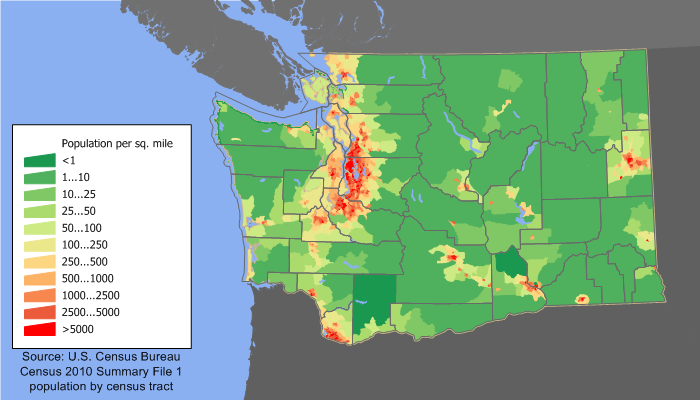
Der er 39 amter i den amerikanske stat Washington. Washington stammer fra den vestlige del af Washington Territory og blev optaget i Unionen som den 42. stat den 11. november 1889. De første amter i området blev dannet allerede fra uorganiseret territorium i midten af 1800-tallet (de tidligste oprettelser fra omkring 1845 og frem). I dag dækker amterne hele staten og fungerer som lokale administrative enheder med ansvar for bl.a. retskredsadministration, lokal infrastruktur og visse sociale tjenester.
Federal Information Processing Standard (FIPS)-koden, som USA's regering bruger til at identificere amter entydigt, er angivet sammen med hver post nedenfor. FIPS-koden for et amt består af statens tocifrede kode (Washington = 53) efterfulgt af amtets trecifrede kode, fx 53033 for King County. FIPS-koderne i listen henviser til de amerikanske folketællingssider med "hurtige fakta" for hvert amt og bruges bredt af statslige og føderale databaser.
Billedgalleri
3 Billeder

Liste over amter i Washington (39) med amtssæde og FIPS-kode
- Adams County — Amtssæde: Ritzville — FIPS: 53001
- Asotin County — Amtssæde: Asotin — FIPS: 53003
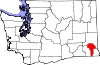
- Benton County — Amtssæde: Prosser — FIPS: 53005
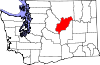
- Chelan County — Amtssæde: Wenatchee — FIPS: 53007
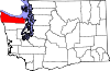
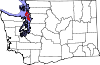
- Clallam County — Amtssæde: Port Angeles — FIPS: 53009
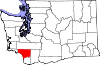
- Clark County — Amtssæde: Vancouver — FIPS: 53011
- Columbia County — Amtssæde: Dayton — FIPS: 53013
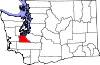
- Cowlitz County — Amtssæde: Kelso — FIPS: 53015
- Douglas County — Amtssæde: Waterville — FIPS: 53017
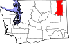
- Ferry County — Amtssæde: Republic — FIPS: 53019
- Franklin County — Amtssæde: Pasco — FIPS: 53021
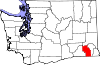
- Garfield County — Amtssæde: Pomeroy — FIPS: 53023
- Grant County — Amtssæde: Ephrata — FIPS: 53025
- Grays Harbor County — Amtssæde: Montesano — FIPS: 53027
- Island County — Amtssæde: Coupeville — FIPS: 53029
- Jefferson County — Amtssæde: Port Townsend — FIPS: 53031
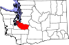
- King County — Amtssæde: Seattle — FIPS: 53033
- Kitsap County — Amtssæde: Port Orchard — FIPS: 53035
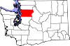
- Kittitas County — Amtssæde: Ellensburg — FIPS: 53037
- Klickitat County — Amtssæde: Goldendale — FIPS: 53039
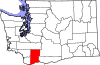
- Lewis County — Amtssæde: Chehalis — FIPS: 53041
- Lincoln County — Amtssæde: Davenport — FIPS: 53043
- Mason County — Amtssæde: Shelton — FIPS: 53045
- Okanogan County — Amtssæde: Okanogan — FIPS: 53047
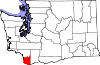
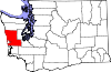
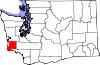
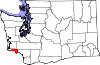
- Pacific County — Amtssæde: South Bend — FIPS: 53049
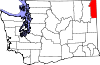
- Pend Oreille County — Amtssæde: Newport — FIPS: 53051
- Pierce County — Amtssæde: Tacoma — FIPS: 53053
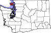
- San Juan County — Amtssæde: Friday Harbor — FIPS: 53055
- Skagit County — Amtssæde: Mount Vernon — FIPS: 53057
- Skamania County — Amtssæde: Stevenson — FIPS: 53059
- Snohomish County — Amtssæde: Everett — FIPS: 53061
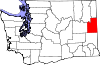
- Spokane County — Amtssæde: Spokane — FIPS: 53063
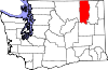
- Stevens County — Amtssæde: Colville — FIPS: 53065
- Thurston County — Amtssæde: Olympia — FIPS: 53067
- Wahkiakum County — Amtssæde: Cathlamet — FIPS: 53069
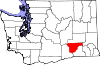
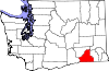
- Walla Walla County — Amtssæde: Walla Walla — FIPS: 53071
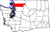
- Whatcom County — Amtssæde: Bellingham — FIPS: 53073
- Whitman County — Amtssæde: Colfax — FIPS: 53075
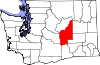
- Yakima County — Amtssæde: Yakima — FIPS: 53077
Bemærk: King County er klart det mest folkerige amt i staten, mens Okanogan County er et af de største målt i areal. For opdaterede befolknings- og økonomiske data for hvert amt kan man konsultere US Census Bureau eller statens egne statistiske kilder (de nævnte FIPS-koder bruges ofte i disse databaser for entydig identifikation).
Liste
| Amt | FIPS-kode | Amtssæde | Etableret | Oprindelse | Betydning af navnet | Befolkning | Område | Kort |
| Adams County | 001 | Ritzville | 1883 | Whitman County | John Adams (1735-1826), USA's anden præsident | 7004187280000000000♠18,728 | 70031925000000000000000♠1,925 sq mi |
|
| Asotin County | 003 | Asotin | 1883 | Garfield County | Nez Percé-navnet for Eel Creek | 7004216230000000000♠21,623 | 70026360000000000000000♠636 km2 |
|
| Benton County | 005 | Prosser | 1905 | Yakima og Klickitat amter | Thomas Hart Benton (1782-1858), en amerikansk senator fra Missouri | 7005175177000000000♠175,177 | 70031703000000000000000♠1,703 sq mi |
|
| Chelan County | 007 | Wenatchee | 1899 | Okanogan og Kittitas amter | Et indiansk ord, der betyder "dybt vand", og som sandsynligvis henviser til Chelan-søen | 7004724530000000000♠72,453 | 70032922000000000000000♠2,922 sq mi |
|
| Clallam County | 009 | Port Angeles | 1854 | Jefferson County | Et Klallam-ord, der betyder "det stærke folk" | 7004714040000000000♠71,404 | 70031745000000000000000♠1,745 sq mi |
|
| Clark County | 011 | Vancouver | 1845 | Oprindelige amt | William Clark (1770-1838), medkaptajn på Lewis og Clark-ekspeditionen | 7005425363000000000♠425,363 | 70026280000000000000000♠628 km2 |
|
| Columbia County | 013 | Dayton | 1875 | Walla Walla County | Columbia-floden | 7003407800000000000♠4,078 | 70028690000000000000000♠869 km2 |
|
| Cowlitz County | 015 | Kelso | 1854 | Oprindelige amt | Cowlitz, en indianerstamme | 7005102410000000000♠102,410 | 70031139000000000000000♠1.139 km2 |
|
| Douglas County | 017 | Waterville | 1883 | Lincoln County | Stephen A. Douglas (1813-1861), amerikansk senator fra Illinois | 7004384310000000000♠38,431 | 70031821000000000000000♠1,821 sq mi |
|
| Ferry County | 019 | Republikken | 1899 | Stevens County | Elisha P. Ferry (1825-1895), 1. guvernør i staten Washington | 7003755100000000000♠7,551 | 70032204000000000000000♠2,204 sq mi |
|
| Franklin County | 021 | Pasco | 1883 | Whitman County | Benjamin Franklin (1706-1790), forfatter, taler, opfinder og USA's grundlægger | 7004781630000000000♠78,163 | 7003124200000000000♠1.242 km2 |
|
| Garfield County | 023 | Pomeroy | 1881 | Columbia County | James A. Garfield (1831-1881), USA's 20. præsident | 7003226600000000000♠2,266 | 70027100000000000000000♠710 sq mi |
|
| Grant County | 025 | Ephrata | 1909 | Douglas County | Ulysses S. Grant (1822-1885), USA's 18. præsident | 7004891200000000000♠89,120 | 70032681000000000000000♠2,681 sq mi |
|
| Grays Harbor County | 027 | Montesano | 1854 | Thurston County | Grays Harbor, en vandmasse opkaldt efter opdagelsesrejsende og handelsmand Robert Gray (1755-1806) | 7004727970000000000♠72,797 | 70031917000000000000000♠1,917 sq mi |
|
| Island County | 029 | Coupeville | 1853 | Thurston County | Whidbey og Camano Islands | 7004785060000000000♠78,506 | 70022090000000000000000♠209 sq mi |
|
| Jefferson County | 031 | Port Townsend | 1852 | Thurston County | Thomas Jefferson (1743-1826), USA's tredje præsident og hovedforfatter af uafhængighedserklæringen | 7004298720000000000♠29,872 | 70031809000000000000000♠1,809 sq mi |
|
| King County | 033 | Seattle | 1852 | Thurston County | William R. King (1786-1853), amerikansk vicepræsident under Franklin Pierce; officielt omdøbt i 1986 efter Martin Luther King, Jr. (1929-1968) | 7006193124900000000♠1,931,249 | 70032126000000000000000♠2,126 sq mi |
|
| Kitsap County | 035 | Port Orchard | 1857 | King og Jefferson Counties | Høvding Kitsap (død 1860), leder af Suquamish-stammen | 7005251133000000000♠251,133 | 700239600000000000000000000♠396 km2 |
|
| Kittitas County | 037 | Ellensburg | 1883 | Yakima County | Kittitas-stammens ord af usikker betydning, med populære oversættelser, der spænder fra "hvidt kridt" til "land med overflod" | 7004409150000000000♠40,915 | 70032297000000000000000♠2,297 sq mi |
|
| Klickitat County | 039 | Goldendale | 1859 | Walla Walla County | Klickitat-stammen | 7004203180000000000♠20,318 | 70031872000000000000000♠1,872 sq mi |
|
| Lewis County | 041 | Chehalis | 1845 | Oprindelige amt | Meriwether Lewis (1774-1809), medkaptajn på Lewis og Clark-ekspeditionen | 7004754550000000000♠75,455 | 70032408000000000000000♠2,408 sq mi |
|
| Lincoln County | 043 | Davenport | 1883 | Whitman County | Abraham Lincoln (1809-1865), 16. præsident i USA | 7004105700000000000♠10,570 | 70032311000000000000000♠2,311 sq mi |
|
| Mason County | 045 | Shelton | 1854 | King County | Charles H. Mason (1830-1859), 1. sekretær for Washington Territory | 7004606990000000000♠60,699 | 70029610000000000000000♠961 sq mi |
|
| Okanogan County | 047 | Okanogan | 1888 | Stevens County | Et salish-amerikansk ord, der betyder "rendezvous" | 7004411200000000000♠41,120 | 70035268000000000000000♠5,268 sq mi |
|
| Pacific County | 049 | South Bend | 1851 | Lewis County | Stillehavet | 7004209200000000000♠20,920 | 70029750000000000000000♠975 sq mi |
|
| Pend Oreille County | 051 | Newport | 1911 | Stevens County | Den amerikanske indianerstamme Pend d'Oreille | 7004130010000000000♠13,001 | 70031400000000000000000♠1,400 sq mi |
|
| Pierce County | 053 | Tacoma | 1852 | Thurston County | Franklin Pierce (1804-1869), 14. præsident i USA | 7005795225000000000♠795,225 | 70031676000000000000000♠1,676 sq mi |
|
| San Juan County | 055 | Fredag Harbor | 1873 | Whatcom County | San Juan Island | 7004157690000000000♠15,769 | 70021750000000000000000♠175 sq mi |
|
| Skagit County | 057 | Mount Vernon | 1883 | Whatcom County | Den amerikanske indianerstamme Skagit | 7005116901000000000♠116,901 | 70031735000000000000000♠1,735 sq mi |
|
| Skamania County | 059 | Stevenson | 1854 | Clark County | Et chinookansk ord, der betyder "hurtigt vand" | 7004110660000000000♠11,066 | 70031656000000000000000♠1,656 sq mi |
|
| Snohomish County | 061 | Everett | 1861 | Island County | Snohomish-stammen | 7005713335000000000♠713,335 | 70032090000000000000000♠2,090 sq mi |
|
| Spokane County | 063 | Spokane | 1879 | Stevens County | Den amerikanske indianerstamme Spokane | 7005471221000000000♠471,221 | 70031764000000000000000♠1,764 sq mi |
|
| Stevens County | 065 | Colville | 1863 | Walla Walla County | Isaac Stevens (1818-1862), 1. guvernør for Washington Territory | 7004435310000000000♠43,531 | 70032478000000000000000♠2,478 sq mi |
|
| Thurston County | 067 | 1852 | Lewis County | Samuel Thurston (1815-1851), Oregon-territoriets første delegerede til USA's kongres | 7005252264000000000♠252,264 | 70027270000000000000000♠727 sq mi |
| |
| Wahkiakum County | 069 | Cathlamet | 1854 | Cowlitz County | Leder af Wahkiakum ("Tall Timber"), indiansk stamme | 7003397800000000000♠3,978 | 70022640000000000000000♠264 sq mi |
|
| Walla Walla County | 071 | Walla Walla | 1854 | Skamania County | Den amerikanske indianerstamme Walla Walla, og også et andet navn for rindende vand | 7004587810000000000♠58,781 | 70031270000000000000000♠1,270 sq mi |
|
| Whatcom County | 073 | Bellingham | 1854 | Island County | Nooksack-ord, der betyder "larmende vand" | 7005201140000000000♠201,140 | 70032120000000000000000♠2,120 sq mi |
|
| Whitman County | 075 | Colfax | 1871 | Stevens County | Marcus Whitman (1802-1847), en presbyteriansk missionær | 7004447760000000000♠44,776 | 70032159000000000000000♠2,159 sq mi |
|
| Yakima County | 077 | Yakima | 1865 | Ferguson County (nedlagt) | Den amerikanske indianerstamme Yakama | 7005243231000000000♠243,231 | 70034296000000000000000♠4,296 sq mi |
|

Tidligere amter
- Ferguson County, der er opkaldt efter James L. Ferguson, lovgiver i Washington, blev dannet den 23. januar 1863 fra Walla Walla County og ophørte den 18. januar 1865. Yakima County blev dannet i stedet.
Relaterede artikler
Forfatter
AlegsaOnline.com Amter i Washington (delstat, USA): Liste over 39 amter og FIPS-koder Leandro Alegsa
URL: https://da.alegsaonline.com/art/124638
Kilder
- wsulibs.wsu.edu : "Historical Timeline of Events Leading to the formation of Washington State"
- historylink.org : "Washington Counties"
- epa.gov : "EPA County FIPS Code Listing"
- naco.org : "NACo - Find A County"
- historylink.org : "Washington Territorial Legislature creates Sawamish (Mason) County on April 15, 1854"
- historylink.org : "Slaughter County is renamed Kitsap County on July 13, 1857"
- historylink.org : "Ferguson County is established on January 23, 1863"
- historylink.org : "Milestones for Washington State History -- Part 2: 1851 to 1900"