Franklin County, Kansas
Franklin County (amtskode FR) er et amt i den østlige del af den amerikanske stat Kansas. I 2010 boede der 25.992 mennesker. Countyets hovedsæde er Ottawa. Ottawa er også den største by i Franklin County. Amtet er overvejende landligt. Det var Kansas City metropolområde, men det er det ikke længere siden 2013.
Geografi
Ifølge det amerikanske Census Bureau har amtet et samlet areal på 577 kvadratmiles (1.490 km2 ). Heraf er 572 kvadrat miles (1.480 km2 ) land og 5,4 kvadrat miles (14 km2 ) (0,9 %) er vand.
Større motorveje
- Interstate 35
- U.S. Route 50
- U.S. Route 59
- K-33
- K-68
Personer
| Historisk befolkning | |||
| Folketælling | Pop. | %± | |
| 1860 | 3,030 | - | |
| 1870 | 10,385 | 242.7% | |
| 1880 | 16,797 | 61.7% | |
| 20,279 | 20.7% | ||
| 1900 | 21,354 | 5.3% | |
| 1910 | 20,884 | -2.2% | |
| 1920 | 21,946 | 5.1% | |
| 1930 | 22,024 | 0.4% | |
| 1940 | 20,889 | -5.2% | |
| 1950 | 19,928 | -4.6% | |
| 1960 | 19,548 | -1.9% | |
| 1970 | 20,007 | 2.3% | |
| 1980 | 22,062 | 10.3% | |
| 1990 | 21,994 | -0.3% | |
| 2000 | 24,784 | 12.7% | |
| 2010 | 25,992 | 4.9% | |
| Est. 2016 | 25,560 | -1.7% | |
| Amerikanske decennieoptællinger | |||
Franklin County ligger i Ottawa, KS Micropolitan Statistical Area. Det var med i Kansas City-Overland Park-Kansas City, MO-KS Combined Statistical Area.

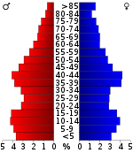
Befolkningspyramide
Regeringen
Præsidentvalg
Franklin County er ofte repræsenteret af republikanske kandidater. Sidste gang en demokratisk kandidat har vundet Franklin County var i 1964 med Lyndon B. Johnson.
Resultater af præsidentvalget
| Resultater af præsidentvalget | |||
| År | Tredjeparter | ||
| 2016 | 65.5% 7,185 | 26.4% 2,892 | 8.1% 888 |
| 2012 | 63.6% 6,984 | 33.6% 3,694 | 2.8% 312 |
| 2008 | 60.0% 7,079 | 37.6% 4,433 | 2.4% 279 |
| 2004 | 64.4% 7,391 | 34.2% 3,921 | 1.4% 164 |
| 2000 | 61.4% 5,925 | 34.4% 3,321 | 4.3% 412 |
| 1996 | 50.9% 5,007 | 36.1% 3,552 | 13.0% 1,276 |
| 1992 | 37.4% 3,699 | 30.0% 2,968 | 32.5% 3,216 |
| 1988 | 56.4% 4,777 | 42.4% 3,592 | 1.1% 96 |
| 1984 | 70.6% 6,284 | 28.4% 2,523 | 1.0% 92 |
| 1980 | 62.7% 5,525 | 31.0% 2,726 | 6.3% 557 |
| 1976 | 55.5% 4,760 | 42.1% 3,607 | 2.5% 211 |
| 1972 | 72.7% 6,011 | 24.9% 2,056 | 2.4% 200 |
| 1968 | 59.2% 4,875 | 30.6% 2,524 | 10.2% 840 |
| 1964 | 45.3% 3,725 | 53.6% 4,410 | 1.1% 86 |
| 1960 | 68.2% 6,158 | 31.3% 2,824 | 0.5% 47 |
| 1956 | 71.4% 6,557 | 28.2% 2,591 | 0.4% 33 |
| 1952 | 72.9% 6,983 | 26.4% 2,532 | 0.7% 69 |
| 1948 | 58.2% 5,145 | 39.3% 3,467 | 2.5% 222 |
| 1944 | 64.7% 5,375 | 34.7% 2,880 | 0.7% 55 |
| 1940 | 63.8% 6,393 | 35.4% 3,542 | 0.9% 85 |
| 1936 | 57.0% 6,007 | 42.7% 4,503 | 0.3% 28 |
| 1932 | 50.2% 4,887 | 48.1% 4,690 | 1.7% 165 |
| 1928 | 78.4% 7,346 | 20.8% 1,951 | 0.8% 73 |
| 1924 | 67.1% 6,008 | 25.9% 2,324 | 7.0% 628 |
| 1920 | 65.2% 5,216 | 32.6% 2,606 | 2.3% 183 |
| 1916 | 45.2% 3,885 | 48.0% 4,128 | 6.8% 588 |
| 1912 | 13.8% 672 | 40.3% 1,970 | 46.0% 2,247 |
| 1908 | 52.7% 2,658 | 42.8% 2,155 | 4.5% 227 |
| 1904 | 62.8% 2,855 | 28.8% 1,310 | 8.3% 378 |
| 1900 | 51.6% 2,872 | 46.8% 2,605 | 1.7% 94 |
| 44.9% 2,609 | 54.3% 3,152 | 0.8% 49 | |
| 1892 | 46.1% 2,209 | 53.9% 2,587 | |
| 1888 | 50.5% 2,422 | 23.2% 1,113 | 26.3% 1,264 |
Uddannelse
Fælles skoledistrikter
- West Franklin USD 287 (websted)
- Central Heights USD 288 (websted)
- Wellsville USD 289 (websted)
- Ottawa USD 290 (websted)
Højskoler og universiteter
- Ottawa University, Ottawa
- Neosho County Community College (campus), Ottawa
Fællesskaber
Byer
- Lane
- Ottawa
- Pomona
- Princeton
- Rantoul
- Richmond
- Wellsville
- Williamsburg

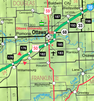
KDOT-kort over Franklin County fra 2005 (kortlegende)
Mere læsning
- Standard Atlas of Franklin County, Kansas; Geo. A. Ogle & Co; 69 sider; 1920.
- Plat Book of Franklin County, Kansas; North West Publishing Co; 36 sider; 1903.
Søge